
Rivergrove Pedestrian Bridge
Project Background
The City of Sumner will build a pedestrian bridge that reconnects approximately 1,500 residents of the Rivergrove neighborhood to services and amenities. Currently, the Rivergrove neighborhood is an “island” surrounded by the flood-prone Puyallup River and cut off from the rest of the city by State Route 410 (SR410). There is limited access in and out of the neighborhood via the often-congested State Route 162 (SR162), an arterial street, Valley Avenue, which lacks sidewalks and a designated bike lane. All residents of this neighborhood must travel by vehicle, with only one signalized intersection for entering and exiting this neighborhood. There are three additional streets that lead out of the neighborhood, but these streets do not have traffic signals, and heavy cross traffic limits these options. The main arterial of Valley Avenue (SR162) is a densely travelled street that experiences significant backups an estimated six hours each day. This situation makes it difficult to access the Rivergrove neighborhood.
This pedestrian bridge provides a viable solution that reconnects residents to key amenities including the regional Sumner Sound Transit Station (regional bus/train to Tacoma, Seattle), elementary, middle, and high schools, parks, stores, the Food Bank, the library, and Downtown Sumner. This bridge will also give Rivergrove residents different transportation mode options, eliminating or reducing the use of vehicles, reducing congestion on SR162/SR410 and promoting physical activity. For perspective, the Sound Transit Station is 1.25 miles away via the bridge but is currently a 1.75-mile trip around SR410 with no pedestrian option. Additionally, the bridge gives residents another safe evacuation option in an emergency. This neighborhood can be threatened by river flooding, urban wildlife and lahars from Mount Rainier. Their current only route out will be gridlock, stranding approximately 1,500 people with no other escape.

Why we're doing this project:
The section of State Route 410 that spans from East Main Avenue to 166th Avenue East was built in 1969 to connect communities and provide access to additional freeway systems such as State Route 167 (SR167) and State Route 512 (SR512). However, the construction of SR410 also divided the City of Sumner by cutting off the Rivergrove neighborhood from the rest of the city, providing those residents with limited access to amenities and pedestrian routes. The residents of the neighborhood currently only have one intersection with another state highway, SR162, with a traffic signal; there is no designated pedestrian path or bike lanes for access to outside of the neighborhood. And there are no sidewalks along SR162, which is the only connection to and from the neighborhood to the rest of the City of Sumner.
These barriers limit approximately 1,500 residents from access to key amenities including schools, parking, and groceries. A Sound Transit train and bus station on the north side of SR410 serves many commuters. Although it is just over a mile from the Rivergrove community, the residents are currently cut off from easy access via walking or biking. Their only safe option is to drive around the SR410 freeway, adding commute time and struggle for limited parking at the station. The train service from this station connects commuters from the City of Sumner to the cities Lakewood, Tacoma, Puyallup, Auburn, Kent, Tukwila, and Seattle. Each of these cities provide a vast number of employment opportunities for those who live within the City of Sumner and the surrounding areas.
Although Sumner looks like small-town Americana, it is part of the booming Puget Sound region and serves as the hub for growing communities like Bonney Lake, Orting, Tehaleh and more. This is where they come to access jobs, transit and the state’s largest YMCA. All this activity, relying on roads like SR410 and SR162 creates congestion that makes people in areas like the Rivergrove neighborhood even more stranded without non-vehicular options to access Sumner’s jobs and amenities.
The Rivergrove neighborhood is the only part of the City of Sumner that is not located on the north side of SR410. When evaluating the city boundaries, this neighborhood is the only portion of the city that does not connect to the rest of the city areas, as seen below in Figure 1. With the construction of SR410 and the construction of the new homes in the Rivergrove neighborhood, the residents are left with limited access to the rest of the city. These residents do not have the same access to the parks, services and amenities within the city that the rest of the residents have, yet they are paying the same taxes as those who live elsewhere within the city. The residents of the Rivergrove neighborhood deserve to have access to the benefits provided by the city in which they live.
In addition, there is an extensive trail system that spans throughout the City of Sumner. It is called the Sumner Link Trail because it provides the connection from the popular Interurban Trail to Seattle and the Foothills Trail to Mount Rainier. This bridge will connect the Rivergrove neighborhood back to the major trail system and with a future second bridge south of Rivergrove over the Puyallup River, will eventually fully connect the Interurban to the Foothills, providing a seamless trail system from Seattle to Mount Rainier through Sumner.
THE SOLUTION
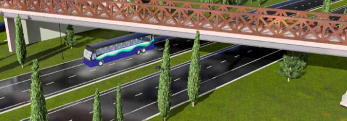
The proposed pedestrian bridge will be located within the City of Sumner, connecting the Rivergrove neighborhood at 143rd Avenue E to the rest of the city at Alder Avenue, as seen below in Figures 1, 2 and 3. The bridge will cross over SR410, which is the barrier dividing the community. The newly constructed bridge will be located within two neighborhood communities that are on the north and south sides of SR410 and allow for the Rivergrove community on the south side of SR410 to be linked with the rest of the City of Sumner. The design for the pedestrian bridge will include ramps for both the north and the south approaches, allowing for walking and rolling to various places within the city. The bridge will also include a flood drainage retention pond under the south approach to account for the possible flooding due to the close vicinity of the Puyallup River. Located at the south approach as well, two new sidewalk curb bulbs will be constructed to allow for the safe access to the new pedestrian bridge.
The estimated total project cost is $11.4 million.

Figure 1 Map of the proposed bridge alignment that will connect the Rivergrove neighborhood to the rest of the city.
 Figure 2 Street view of where the bridge approach will be located, on the south side of SR410.
 Figure 3 Street view of where the bridge approach will be located on the north side of SR410.
Q & A
Ask Project Manager Andrew Leach your question(s) about the project and its construction.
Who's Listening
-
Phone 253-299-5711 Email andrewl@sumnerwa.gov
Thank you for your contribution!
Help us reach out to more people in the community
Share this with family and friends